

The Empire Pass is located on the North side of Lawson in the Blue Mountains of NSW which can be done as both a circuit or a one way walk. It was constructed in the very early 1900's and opened on Empire Day in 1913 to much fanfare, Lawson is well known for its great walking tracks and waterfalls. Depending on where you choose to start, you can either start at the carpark at the end of St Bernards Drive down past the Lawson Swim Centre or you can start at the end of Hughes Ave. I'll describe the walk from the main carpark nearest to Fairy Falls.
Just a quick word, this track has a LOT of steps to contend with and a number of creek crossings with slippery stepping stones, just remember, it does not matter which way you do this walk, what goes down, must eventually come back up. There are also section of the track that are quite narrow, unfenced and high above the creek, so small children may need good supervision.
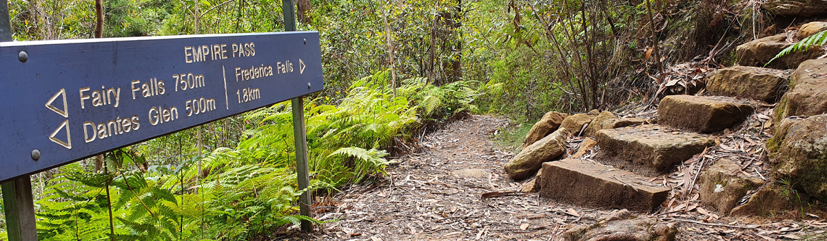
After parking your car in some shade, head on down through the reserve here towards the track information sign, it will give you some information about the walk, now start to head down the walking track in front of you, a few wooden steps that like to hold water after rain and in a few minutes you will come to a branch track that goes right, this will take you across to Fairy Falls and further on to Echo Bluff and the tracks up on top of the hills here. At the very least, go visit Fairy Falls, then come back the way you just walked, turn right and start your descent into Dante's Glen which is the next waterfall on this circuit. There are a lot of old stone steps that take you down, down, down into the Glen and across a bridge.
Just as you arrive at Dante's Glen, before you descend to the bridge, there is a rough short track on the left that puts you on a ledge above the water and sand below for a different angle of the falls. Cross the bridge and head down onto the sand below the falls, these are some nice falls to visit, and there are a lot of names carved into the boulder in the middle of the sandy area. Turn around and start to follow the track downstream, you will come to a sign and the track appears to continue following the creek on the left bank, it does not, cross the creek here carefully, and then again cross another side creek, you will have just arrived at an old picnic table and a sign pointing to St Michael's Falls to your right.
Start heading up towards the falls, crossing the creek again and then a few minutes later you will arrive at St Michael's Falls, another nice set of falls to enjoy and you may have also noticed another old picnic table on the right just as you arrived at the falls, there were a number of these installed on this walk including a now long gone shelter shed further around on the main walk. Once the watery goodness is fully absorbed, head back down to where you branched off, have a look on the rock face on the right as you start up a couple of steps for an old hand-painted sign mentioning the falls are 60yards away, a bit of cool old history. No more waterfalls to be see for quite some time and now you are going to start the main part of the walk.
For the next couple of kilometers you will be walking on a well-formed walking track that follows the creek, crossing it in a few places with slippery stepping stones, don't trust em or wet feet or worse will be the result. The track starts out at creek level but eventually will climb quite a way above the creek, it can be quite narrow in places with no fences so if you slip, you will be in the creek shortly thereafter, you really do not want to do that, keep an eye on small children through these sections. You will come to the creek level again and the track continues on the otherside, but there is a nice cascade just up the creek from the crossing, you can see it pretty easily. Now you are on the left side of the creek.
Some more undulating walking along and again you will soon need to cross the creek again on some boulders, just be careful with your rock-hopping here, you may not see them coming from this direction, but there are some shallow steps cut into the rock here, there is also a nice pool here you could cool off in. Now on the other bank, you start to climb up a bit and you are below Echo Bluff way above, some great echos can be heard if you choose to visit there someday. As you curve around the bluff above you will now start to follow another creek, at the junction below of these two creek was the location of the old shelter shed and a swimming hole.
The track now continues to undulate up and down as you start to head towards Frederica Falls, they are still a bit of distance away though and a fair amount of steps and heading uphill, your legs will love it! There is an old side track you will pass on your left that takes you down to Lucy's Glen with an old moss-covered bench seat. If you are an experienced scrambler and can navigate off-track you could visit a great waterfall hidden way off the beaten track. Keep heading up the track which can get muddy in places depending on when it last rained. The uphill is the gift that keeps on giving, you pass a National Parks sign and another muddy patch and it is not too much further and you will arrive at Frederica Falls which are a great set of cascades with a number of levels before plunging over and overhang into the pool below, yup, you can swim at this one, just watch out for underwater logs and rocks.
When you are suitably cooled down and ready to continue, follow the track up to the fire trail that the creek flows across, directly in front of you there is a cool little tumble of water, worth a look. You have a couple of choices on how to complete your walk now, to complete it as a one way hike, take the narrow path to the right of the little cascade and it will follow the creek before climbing up to under the power lines above and eventually to the end of Hughes Ave. If you wish to return back to your car near Fairy Falls, take the fire trail to the right, a few hills and sun to contend with but not too bad, once you get to the locked gate at the top of a long hill, keep going straight ahead, the track on the left takes you to the end of Hughes Ave and on the right out to Echo Bluff.
You will come to a big power line tower on the left with another fire trail going right, take this and you start going down, there are now signs that will take you downhill back to the reserve and carpark where you left your car, just follow the signs to Fairy Falls / Dante's Glen etc. A great way to fill in a few hours on a lazy Sunday., get the heart pumping and see some great Lawson Waterfalls.


