

This walking track that starts at multiple locations at the back of Springwood descends down to the junction of the Victory walking track down on Glenbrook Creek, the track follows Magdala Creek and is about 50% downhill and 50% flat or mildly undulating with a total descent of around 180-200mtrs. I chose to start my walk from Picnic Point where there is some shade and parking, plus a garbage and picnic shelter, then a set of reasonable stone and timber steps winds down to the creek and a bridge to join the main walking track, if you went left you would end up in the back of Springwood via Fairy Dell Reserve.
So after turning right you start to slowly descend with the creek on your right, aver time your cross the creek many times in places as you head down, after a short time you will come across the first branch off track, this one ascends up to Lawson's Lookout and onto the end of Raymond Road, so we go down some slippery stone steps beside a small cascade, you can see there used to be wooden fence along this section of stone from the square holes in the stone. We continue walking beside the creek and soon we cross the creek again and continue to walk through a nice shaded section of forest before coming to a wooden stepped ramp with a nice waterfall (unnamed) with a pool at the bottom.
Along a bit further, you will come to a wooden sign, a track crosses the creek here, but that is not the way we are going. This track goes up a gully to a network of tracks down behind Blue Gum Lodge, there is even the remains of an only stone/concrete dam in the creek, no silted up that may have been made to create a swimming hole. More creek crossings and ducks, keep on going downwards, crossing the creek and wandering under overhangs and again a creek crossing with some nice old cut stone steps, up a bit to another set of signs, one trying to block another track on the left. This track winds its way up and comes out at Batman Park on Farm Road, keep that for another time, we got places to go.
More overhangs and you will come to a wide, open creek crossing with a little cascade on your right, down to the left, the creek disappears down into a hole and into the pool below, the water must enter this pool under the surface of the water. Looks like you could have a swim in this pool on a hot enough day. Keep on going, more shady walking and overhangs and soon you will come to the sign for Magdala Falls, a rough track to the left will take you to a sheer drop above the falls, but due to foliage, you won't get much of a look at the falls or the Blue Pool below. This edge or the rough track to it are really not safe for small children at all.
If you really want to see the falls, keep following the main track and you will come to a dry, dusty overhang and the walking track goes left and down, you can scramble down here to the creek level and walk back up to the falls. This scramble has plenty of slippery rocks, leaf litter and my personal favorite - Lawyer Vine. Once you are at the base of the falls, you will see just why the pool here is called the Blue Pool, just stunning.
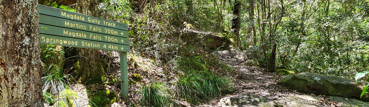
So, continuing along for another 300mtrs or so and you will arrive at Martin's Falls, if there is not much water flowing, they are not exactly great to look at, there is a pool at the bottom, yes, you could cool off, but not actually deep enough to swim. There are two signs here for Martin's Falls, one up on a tree, the track behind this one takes you down to the pool, the other wider sign has a natural ledge behind it that will get you access to the back of the falls with care.
From here, you are about 300mtrs away from the end of the walk, some more downhill and you arrive at Perch Ponds on Glenbrook Creek, a popular campsite on the Victory Track which you just arrived at. If you go left you can go downstream to Martin's Lookout, if you go right, you can get as far as Faulconbridge, with a couple of other tracks branching off to head back to Springwood. Here is a good spot to have a break before either going left, right, or going back the way you came. I returned the way I came, had no reasons to stop much on the way back apart from wetting my hat in the creek and occasionally stopping to catch my breath, it took me 70-75 minutes to get back to the car.
Best to do this walk after plenty of rain, so long as you can still cross the creek, and in cooler weather. Suitable for kids, but anyone doing this track needs a reasonable level of fitness due to all the uphill on the way back. Total distance nearly 9kms return from Picnic Point.


