

A few months ago, the boy and I were out doing an OSM walk mapping the tracks out in a particular area of the Northern side of Faulconbridge, on our way back, I noticed a very feint track heading east off the firetrail we were walking on, we followed it for about 150mtrs or more and saw it was heading back down into the valley between this and the ridge to the east. We had already just walked up out of a steep valley at the end of the point we were on and could not be bothered doing it again today. So I put it into the back of my mind for a return visit.
Today I came back with the sole reason to follow this track to see what I would find and see where the track went, mapping it into OSM when I returned home. From where I stopped last time, the track sloped away gradually at first and then the mini cliff lines started, nothing bigh, just rocky drops that ended up looking like a creekbed when it rained. I weaved back and forwards until I could see the valley floor not far below.
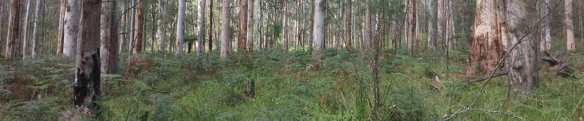
I reached the valley floor, or at least the final slope before it and here and there, I had been following pink tape markers here and there. I stopped and looked around, no more markers, guess that is the end of the track, so decided to just go for a wander amungst the massive gum trees that were growing here. Some of these gum trees looked like you would need 6-8 people to hug around the base just to reach around the entire girth. There were a few trees of this size growing here. I had a bit of a wander, the ground was native grasses and ferns, very pretty area really.
I could find no evidence in the parts I walked to, that showed that anyone had camped down here which was a nice change. There were so many stunning tall gum trees, similar to Blue Gum Forest, but not as overgrown as that location is now.
I continued to look around and noticed there was a creek, so headed in that direction, it was full of life and as I arrived, something large jumped into the water, no idea what it was, did not see it or the ripples, could have been a large lizard. The creek was flowing quite well and not much evidence of rubbish was to be found that had been washed down from upstream. Talking of upstream, Peggys Pool is a ways upstream from here.
I was going to walk downstream to an area where I could see a small rise in the valley floor and look over there, whilst looking over the other side of the creek, I thought, that seriously looks like a track on the other side. I found a spot to cross a bit further downstream and sure enough, a track lead away from the creek heading east.
I followed this until it crossed another dry creek and started to head up the ridge to the east. A bit of a scramble in places but easy to negotiate, the further I got up along this track, the better and more well defined this track became until it was a full blowen defined walking track. I kept following this as it climbed further up the ridge until I could see I was approaching a fence with signs, crap, like 5 signs saying private property, stay out. I was now next to Grose Road, I decided, hmmm, ok, I'll turn back and head back down and out the way I came, went about 100mtrs and decided, bugger it, I'll exit here and road bash it back around. Not much fun doing a 3.5k road bash in the heat.
I looked at the LPI data as to why this may have been private property, looks like the quarry above the walking track owns a lot of this, so when I put it all into OSM, I marked the track in their property as private access.
A stunning location, with next to no signs of humans having visited and destroyed the place, amazing trees, a small oasis in an urban jungle and just 15-20 minutes from the car. I'll be back to have a bit more of an explore around as I have learned of a small waterfall a bit further downstream.


