

A mate and I were chasing a cache down in the bowels of the Jamieson Valley and I was looking for an alternate way to access the part of the valley we needed to, that was when I read about Copeland pass that descends the nose of Sublime Point at Leura.
Not only is Sublime Point one of the best vantage points in the mountains, it is also a hotspot for climbers at the moment and they make use of Copeland Pass to get to their usual staging points. At the base of Copeland Pass is a very old and historic walking track called the Lindeman Track, this track winds it's way around the base of the cliffs from Gladstone Pass at Wentworth falls to the base of Leura cascades, we followed it for a few hundred meters and the track that we followed was in very good condition.
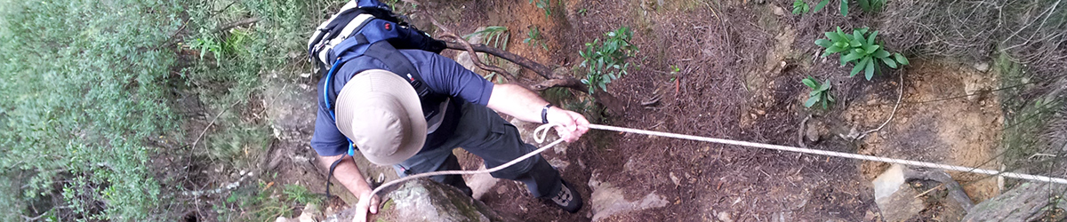
Copeland Pass is NOT a tourist track, it is NOT suitable for children, it has 3 fixed hand lines and plenty of slippery scrambles to negotiate, it should really only be used by experienced walkers who are happy to scramble etc.
Some History
William Raeburn Copeland (1855-1928) was a Scot, a direct descendant of the artist Sir Henry Raeburn, who arrived in Australia in 1882 and the following year settled in Katoomba. Here he established himself initially as a builder and, in subsequent years, a timber merchant, grocer and general provider. He served as an alderman on the Katoomba Municipal Council, involved himself in numerous church and community affairs and expressed a genuine engagement with the landscape through walking. One of his walks attained a special status.
In 1893, probably descending into the valley at Leura Falls where track making was beginning to gather momentum, Copeland struck off into the bush via an uncertain, eastward route. He crossed the Jamison Valley to the head of Sublime Point where he made a steep and difficult climb out, pioneering what has become known today as the Copeland Pass.
(Sourced from http://bluemountains.org.au/documents/hutnews/web/1104news.pdf page 11)
Basic Walk Information
One Way Distance: 800mtrs
Time One Way: 35 minutes
Starting Altitude: 808mtrs
Highest Altitude: 808mtrs
Lowest Altitude: 676mtrs
How To Get There
Sublime Point is pretty easy to get to, it is one of the major lookouts at Leura, so, just follow the signs.
The Walk
25th March 2012
Leaving your car at the car park at Sublime Point, walk down the tourist track and cross the concrete "bridge" to access the two lookouts here, the views are worth the extra few mtrs. Then, return back to where the hand rail starts and leave the concrete path on the right and start to descend the gully here. You quickly head to the right and it is not far to the first fixed hand line, an easy little scramble. Then, another bit of a scramble and you arrive at the hole in the ground with another fixed hand line, if you have anything on larger than a day pack, pass them down, I just fitted with my day pack on.
A bit more walking along the narrow track and you come to the highest of the fixed hand lines with a big tree root, nothing hard really about any of these fixed line descents. Not long after this you are walking towards the right hand side of the nose of the point where it juts out into the valley, again, a bit of a scramble using trees and roots takes you down on the right. Again, following the winding track, you eventually come to a large but shallow overhang and ledge area, this seems to be where the climbers continue on around the cliff, if you are continuing on to the bottom, look for some yellow electrical tape on the left in a gully.
Now it really can get slippery with all the dry leaves on the "track", from time to time you will see electrical tape on the trees, but the route is pretty easy to follow without seeing the tape, eventually, you can see you have come to a bit of a drop, a false track looks like it leads straight ahead to the drop, you want to continue to the right, it is here that the track can get a tad obscure. Just keep going and not long afterwards you will come to a gully / creek bed, full of pine type needles which are quite deep and again, slippery. Pick a route down this gully and you are almost at the junction of the pass and the Lindeman track.
Shortly after this gully, the vegetation opens up and you soon come to the junction of the Lindeman Track, complete with cairn to mark the spot. Don't dally here too long as there were plenty of leeches to keep us hopping and moving on pretty quickly.
Some Basic stats, and it is pretty hard to keep a good GPS fix on this trek due to the cliffs...
We started at 8:30am and were down in 35 minutes, thats with taking time to stop and take photos and it was our first time down.
Descent looks to be around 140+mtrs or so, I have the top at 808mtrs and the Lindeman Track at around 676mtrs. For what it is worth, I'll show the elevation profile below.
Walking distance is shown as 800+mtrs, but could be less with all the bouncing around the GPS track is.
This could of course be used to ascend out of the Jamieson Valley, but would take some effort to get to the base through some pretty unforgiving valley floor bush.
Elevation Profile
Image Gallery


