

Dargans Arch is not that well known spot that is hidden within the Blue Mountains National Park, not far from Bell on the Bells line of road as you head towards Lithgow from Sydney or Mt Victoria. The walk itself is very easy, some mild downhill along an old 4WD track, then some single track walking that is difficult to see in some places as you get closer to the little canyon this is hidden in. Suitable for kids with care, especially when walking over the arch and scrambling down into the canyon to reach the inside of the arch cave and the 2 other wind-eroded caves next to it further along the canyon.
It will take you on average 20-30 minutes to walk in, less if you are not stopping to take pictures of wild flowers and the views, it is a pretty short track.
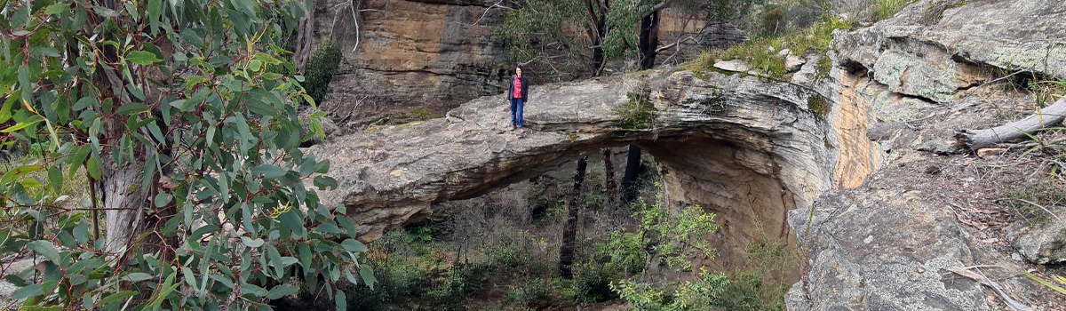
The arch was formed a long time ago when the roof of a large wind eroded cave finally collapsed, forming the arch and the large skylight, it is spectacular to view from many angles, both above and within. The floor of the arch slopes up to the back where the roof collapsed, it is easy scrambling to give you different views of the arch itself and the canyon outside, just take care if it is wet when scrambling.
To the right of the arch are 2 more large wind eroded caves, very cool to view and explore, there are climbing bolts and anchors within the last cave, and may have been in the others but I missed seeing them. Pretty sure climbing of the arch is banned by National Parks, so don't be doing that.
You can either return the way you got into the canyon, or, like we did, scramble around to the right of the last cave and scramble back up on top via a sloping "pass", probably not the easiest for small kids or if you are not used to off-track scrambling. At the very least, the views up and down the creek from here are nice too.
How To Get There
Easy to find and get to and a 2WD is all you need! Navigate to Sandham Rd Bell, NSW, then, follow Sandham Rd for approx 3.6km where a dirt track goes right to under the power lines and then continues into the trees. From that point, it is 4WD or walking, you can get and park a 2WD under the power lines without issue. Park, and follow the 4WD track down the hill, cannot miss it or lose it. After a while, the 4WD track stops, and the single track section starts, but you are now only a few hundred mtrs from the arch, the track in about 50% of this part is defined, but there are sections where it is not, there is the odd bit of pink or orange flagging tape tied to trees here and there. You should also notice where others have walked, broken branches etc, shortly, you start to descent toward the canyon on a rocky slope, if you are in the right spot, if you look left, you will see a rather large hole, you have arrived.
You can cross the arch (Watch kids) and get photos from a number of vantage points, then if you wish to get into the arch, another scramble is involved. Look down and left from the arch and you will see a sloping rock slope that goes into the canyon, it looks steep, but it is not too bad, if wet, might be a different case, a rock has been wedged at the bottom for a final step down. Turn right, cross a fallen tree and a track will lead you into the cave itself within a few seconds. Again, take care with kids coming down that slope with them, you can return to your car this way as well.
Checkout the map below for the starting / parking point, you will see the walking track as well. This is not in Google Maps, but is clearly defined in Open Street Map, there are many good Apps that use OSM maps to help you with navigation, I use OSMAnd.
Video
Gallery


